Awesome-Remote-Sensing-Agents

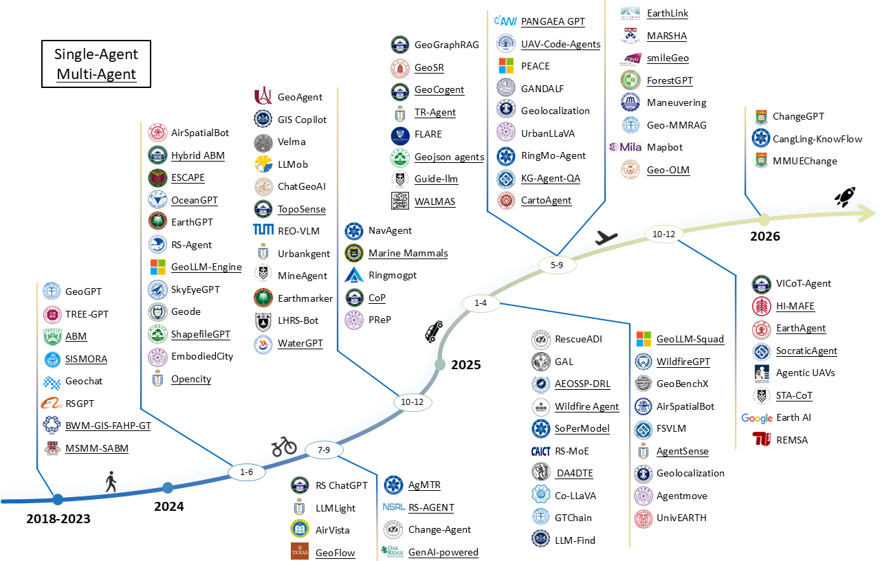
🛰️ A curated collection of 100+ papers at the intersection of Intelligent Remote Sensing Agents 🚀
[!IMPORTANT] We welcome community contributions to keep this list up-to-date!
- 📝 Add missing papers via Pull Request
- 🏷️ Propose new or refined categories
- 🔗 Report broken links or outdated entries
- 💬 Reach out via Contact for any discussion
If you find this survey or repository useful in your research, please cite our paper:
@article{tang2025intelligent,
  title={Intelligent Remote Sensing Agents: A Survey},
  author={Tang, Jiaqi and Yan, Yingying and Wang, Qianzhou and Xia, Yuyang and Geng, Botong and Chen, Jianmin and Ma, Ke and Zhai, Youyang and He, Qingfeng and Shao, Weigeng and Sun, Yunjin and Dai, Junwei and Chen, Chuxi and Xu, Xiaogang and Yao, Kelu and Zhang, Lei and Wei, Wei and Chen, Qifeng and Plaza, Antonio and Zhang, Yanning},
  year={2026},
  url={https://github.com/PolyX-Research/Awesome-Remote-Sensing-Agents}
}
🔥 News
- [2026.06.05] 🚀 Added the latest 2026 remote sensing agent works — GeoMMAgent, RemoteAgent, OpenEarth-Agent, OpenEarthAgent, and GeoEvolver — plus the new OpenEarth-Bench and GeoMMBench benchmarks.
- [2026.04.15] 🎉 Our survey is now available on ResearchGate.
- [2026.03.20] 🎉 The survey is now available on GitHub.
- [2026.03.20] 🎉 We release the Awesome-Remote-Sensing-Agents repository.
📚 Contents
- 🔥 News
- 📚 Contents
- Papers — 🌿 Ecological Monitoring · 🚨 Emergency Response · ⛏️ Geological Exploration · 🌊 Marine Supervision · 🌾 Precision Agriculture · 🏙️ Urban Governance · 🧩 Others
- Datasets & Benchmarks
- 🤝 How to Contribute
- 📄 License
- ✨ Star History
- ✉️ Contact
| Badge | Meaning |
|---|---|
| Preprint on arXiv | |
| Published at a conference or journal | |
| Code repository available | |
| Application domain | |
| Agent design category (planning, memory, tool use, etc.) |
Papers
🌿 Ecological Monitoring (22)
Title
Application & Tags
Links
PCA-OS: A Planetary Climate Adaptation Operating System

REMSA: An LLM Agent for Foundation Model Selection in Remote Sensing
ForestGPT and Beyond: A Trustworthy Domain-Specific Large Language Model Paving the Way to Forestry 5.0
GANDALF: A LLM-based Approach to Map Bark Beetle Outbreaks in Semantic Stories of Sentinel-2 Images
CLEAR: Climate Policy Retrieval and Summarization Using LLMs
DA4DTE: An Agentic System for Enhancing the Accessibility of Digital Twins of Earth
EarthLink: A Self-Evolving AI Agent for Climate Science
A Self-Evolving AI Agent System for Climate Science
Towards LLM Agents for Earth Observation
Accelerating Earth Science Discovery via Multi-Agent LLM Systems
GeoRSMLLM: A Multimodal Large Language Model for Vision-Language Tasks in Geoscience and Remote Sensing
CangLing-KnowFlow: A Unified Knowledge-and-Flow-fused Agent for Remote Sensing Applications
Google Earth AI and Gemini for Climate and Environmental Analysis
REO-VLM: Transforming VLM to Meet Regression Challenges in Earth Observation

VHM: Versatile and Honest Vision Language Model for Remote Sensing Image Analysis

LHRS-Bot: Empowering Remote Sensing with VGI-Enhanced Large Multimodal Language Model

RS-LLaVA: A Large Vision-Language Model for Joint Captioning and Question Answering in Remote Sensing Imagery

EarthGPT: A Universal Multimodal Large Language Model for Multisensor Image Comprehension in Remote Sensing Domain
Transfer Learning in Environmental Remote Sensing
TREE-GPT: Modular Large Language Model Expert System for Forest Remote Sensing Image Understanding and Interactive Analysis
An Agent-Based Model to Represent Space-Time Propagation of Forest-Fire Smoke
High-Resolution Mapping of Global Surface Water and Its Long-Term Changes
🚨 Emergency Response (14)
Title
Application & Tags
Links
FIRE-VLM: A Vision-Language-Driven Reinforcement Learning Framework for UAV Wildfire Tracking
UAV-CodeAgents: Scalable UAV Mission Planning via Multi-Agent ReAct and Vision-Language Reasoning
Geospatial Artificial Intelligence for Satellite-based Flood Extent Mapping

A RAG-Based Multi-Agent LLM System for Natural Hazard Resilience and Adaptation

Earth AI: Unlocking Geospatial Insights with Foundation Models and Cross-Modal Reasoning
Empowering LLM Agents with Geospatial Awareness: Toward Grounded Reasoning for Wildfire Response
A Conceptual High Level Multiagent System for Wildfire Management
RescueADI: Adaptive Disaster Interpretation in Remote Sensing Images With Autonomous Agents
LLM-Enhanced Disaster Geolocalization Using Implicit Geoinformation from Multimodal Data: A Case Study of Hurricane Harvey
Knowledge-Guided Large Language Models for Enhancing Agent-Based Wildfire Spatial Simulation
Large-Language-Model-Driven Agents for Fire Evacuation Simulation in a Cellular Automata Environment
From Perceptions to Decisions: Wildfire Evacuation Decision Prediction with Behavioral Theory-informed LLMs
ESCAPE: Evacuation Simulation Using Cognitive Agent-Based Modeling on Possible Earthquake in GAMA Platform for the Case of Kalayaan Residence Hall
Description of Wildfires Spreading and Extinguishing with the Aid of Agent-Based Models
⛏️ Geological Exploration (7)
Title
Application & Tags
Links

Thinking with Map: Reinforced Parallel Map-Augmented Agent for Geolocalization

PEACE: Empowering Geologic Map Holistic Understanding with MLLMs
STA-CoT: Structured Target-Centric Agentic Chain-of-Thought for Consistent Multi-Image Geological Reasoning

Automating Geospatial Vision Tasks with a Large Language Model Agent
A Vision-Language Foundation Model-Based Multi-Modal Retrieval-Augmented Generation Framework for Remote Sensing Lithological Recognition
HI-MAFE: Hyperspectral Image Multi-Agent Deep Reinforcement Learning Feature Extraction
MineAgent: Towards Remote-Sensing Mineral Exploration with Multimodal Large Language Models
🌊 Marine Supervision (5)
Title
Application & Tags
Links
OceanAI: A Conversational Platform for Accurate, Transparent, Near-Real-Time Oceanographic Insights
Large Language Model-Based Decision-Making for COLREGs and the Control of Autonomous Surface Vehicles
Autonomous Vehicle Maneuvering Using Vision–LLM Models for Marine Surface Vehicles
OceanGPT: A Large Language Model for Ocean Science Tasks
WaterGPT: Training a Large Language Model to Become a Hydrology Expert
🌾 Precision Agriculture (7)
Title
Application & Tags
Links
AgriGPT: A Large Language Model Ecosystem for Agriculture
ChatLeafDisease: A Chain-of-Thought Prompting Approach for Crop Disease Classification Using Large Language Models
RS-MoE: A Vision–Language Model With Mixture of Experts for Remote Sensing Image Captioning and Visual Question Answering
Identifying Potential Rural Residential Areas for Land Consolidation Using a Data-Driven Agent-Based Model
Planning to ‘Hear the Farmer’s Voice’: an Agent-Based Modelling Approach to Agricultural Land Use Planning
A Framework for Data-Driven Agent-Based Modelling of Agricultural Land Use
An Agent-Based Model to Simulate the Cultivation Pattern Change of Farmer Households in the North China Plain
🏙️ Urban Governance (27)
Title
Application & Tags
Links
MMUEChange: A generalized LLM agent framework for intelligent multi-modal urban environment change analysis
AgentSense: LLMs Empower Generalizable and Explainable Web-Based Participatory Urban Sensing
SoPerModel: Leveraging Social Perception for Multi-Agent Trajectory Prediction

AirSpatialBot: A Spatially Aware Aerial Agent for Fine-Grained Vehicle Attribute Recognition and Retrieval
LLM Agent Framework for Intelligent Change Analysis in Urban Environment Using Remote Sensing Imagery

UrbanLLaVA: A Multi-Modal Large Language Model for Urban Intelligence with Spatial Reasoning and Understanding

Automating Traffic Model Enhancement with AI Research Agent
Roads: Robust Prompt-Driven Multi-Class Anomaly Detection Under Domain Shift
A Spatiotemporal–Semantic Coupling Intelligent Q&A Method for Land Use Approval Based on Knowledge Graphs and Intelligent Agents
NavAgent: Multi-scale Urban Street View Fusion For UAV Embodied Vision-and-Language Navigation
GenAI-Powered Multi-Agent Paradigm for Smart Urban Mobility: Opportunities and Challenges for Integrating Large Language Models (LLMs) and Retrieval-Augmented Generation (RAG) with Intelligent Transportation Systems
AgentMove: Predicting Human Mobility Anywhere Using Large Language Model Based Agentic Framework
Perceive, Reflect, and Plan: Designing LLM Agent for Goal-Directed City Navigation Without Instructions

UrbanKGent: A Unified Large Language Model Agent Framework for Urban Knowledge Graph Construction
Large Language Models as Urban Residents: An LLM Agent Framework for Personal Mobility Generation
Guide-LLM: An Embodied LLM Agent and Text-Based Topological Map for Robotic Guidance of People with Visual Impairments

OpenCity: A Scalable Platform to Simulate Urban Activities with Massive LLM Agents
TopoSense: Agent-Driven Topological Graph Extraction from Remote Sensing Image

GeoChat: Grounded Large Vision-Language Model for Remote Sensing

3D Question Answering for City Scene Understanding

VELMA: Verbalization Embodiment of LLM Agents for Vision and Language Navigation in Street View
EmbodiedCity: Embodied Aerial Agent for City-Level Visual Language Navigation Using Large Language Model
AirVista: Empowering UAVs With 3D Spatial Reasoning Abilities Through A Multimodal Large Language Model Agent
LLMLight: Large Language Models as Traffic Signal Control Agents
GeoGPT: Understanding and Processing Geospatial Tasks through An Autonomous GPT
Optimum landfill site selection by a hybrid multi-criteria and multi-Agent decision-making method in a temperate and humid climate: BWM-GIS-FAHP-GT
Urban Change Detection for Multispectral Earth Observation Using Convolutional Neural Networks
🧩 Others (20)
Title
Application & Tags
Links
GeoMMAgent: Toward Expert-Level Multimodal Intelligence in Geoscience and Remote Sensing
RemoteAgent: Bridging Vague Human Intents and Earth Observation with RL-based Agentic MLLMs
OpenEarth-Agent: From Tool Calling to Tool Creation for Open-Environment Earth Observation

OpenEarthAgent: A Unified Framework for Tool-Augmented Geospatial Agents
GeoEvolver: Experience-Driven Multi-Agent Systems Are Training-free Context-aware Earth Observers
VICoT-Agent: A Vision-Interleaved Chain-of-Thought Framework for Interpretable Multimodal Reasoning and Scalable Remote Sensing Analysis
Designing Domain-Specific Agents via Hierarchical Task Abstraction Mechanism

Earth-Agent: Unlocking the Full Landscape of Earth Observation with Agents

GeoFlow: Agentic Workflow Automation for Geospatial Tasks
RingMo-Agent: A Unified Remote Sensing Foundation Model for Multi-Platform and Multi-Modal Reasoning
An energy-efficient learning solution for the Agile Earth Observation Satellite Scheduling Problem
Multi-Agent Geospatial Copilots for Remote Sensing Workflows

Co-LLaVA: Efficient Remote Sensing Visual Question Answering via Model Collaboration
GIS Copilot: Towards an Autonomous GIS Agent for Spatial Analysis
Swarm Intelligence in Geo-Localization: A Multi-Agent Large Vision-Language Model Collaborative Framework
Chain-of-Programming (CoP): Empowering Large Language Models for Geospatial Code Generation Task

RS-Agent: Automating Remote Sensing Tasks through Intelligent Agent

Change-Agent: Towards Interactive Comprehensive Remote Sensing Change Interpretation and Analysis

Remote Sensing ChatGPT: Solving Remote Sensing Tasks with ChatGPT and Visual Models
GeoLLM-Engine: A Realistic Environment for Building Geospatial Copilots
Datasets & Benchmarks
Training and evaluating remote sensing agents requires resources that go beyond static image-label pairs. Agents must integrate visual perception with reasoning, planning, and tool execution. We organize datasets and benchmarks into three tiers: Perception, Reasoning, and Decision-Making.
🗂️ Datasets
| Category | Name | Size | Description |
|---|---|---|---|
| Perception | UC Merced Land Use | 2.1K images | Land-use classification |
| AID | 10K images | Standard scene classification | |
| xView | ~1M instances | Object detection in overhead imagery | |
| DOTA | 188K instances | Oriented object detection | |
| iSAID | 655K instances | Instance segmentation | |
| xBD | 850K instances | Building damage assessment | |
| EuroSAT | 27K images | Land use/land cover classification | |
| LEVIR-CD | 31K instances | Building change detection | |
| Topo-boundary | 25K images | Road topology extraction | |
| STAR | 210K instances | Scene graph generation | |
| SSGD | 3.1K instances | Spatial scene graph retrieval | |
| GID | 150 images | Land-cover classification (GF-2) | |
| FBP | 5B pixels | Country-scale semantic segmentation | |
| WUSU | 68K instances | Urban semantic understanding | |
| RealScene-ISTD | 739 images | Infrared UAV small-target detection | |
| Reasoning | ETH/UCY & nuScenes | 9K+1.4M | Trajectory prediction |
| AirSpatial | 206K instructions | Embodied spatial reasoning | |
| LEVIR-MCI | 10K pairs | Semantic change understanding | |
| GeoChat | 318K instances | Multimodal instruction following | |
| SkyEye-968k | 968K samples | Multi-task instruction tuning | |
| RSICap | 2.6K pairs | High-precision vision-language alignment | |
| UData | 353K instances | Cross-modal urban reasoning | |
| EarthVQA | 208K QA pairs | Relational VQA | |
| VersaD | 1.4M pairs | Rich-content RS image-text captions for pretraining | |
| HnstD | 44K instructions | Honest instruction dataset with factual and deceptive questions | |
| RS-VL3M | 3M pairs | Vision-language pretraining | |
| Decision-Making | RS-Agent | 18 tasks | Expert-guided tool invocation |
| RescueADI | 13.4K interactions | Adaptive disaster response | |
| AEOS-Bench | 16.4K scenarios | Constellation scheduling |
📊 Benchmarks
| Category | Name | Feature | Scale |
|---|---|---|---|
| Perception | AgMTR | Few-shot segmentation | 5 test classes |
| TopoSense | Graph extraction | 2,685 images | |
| TREE-GPT | Interactive forest RS | 3 tiles | |
| STAR | Scene graph generation | 1,273 images | |
| Univ-1652 | Geo-localization | 1,652 buildings | |
| SSGD | Relationship retrieval | 3,130 samples | |
| EarthView | Large-scale pretraining | 15 terapixels | |
| Reasoning | AirSpatial-Bench | Spatial retrieval tasks | 1,773 pairs |
| RSVQA | Remote sensing QA | 77K–1M questions | |
| XLRS-Bench | Ultra-high-res reasoning | 45,942 questions | |
| RescueADI | Disaster interpretation | 998 tasks | |
| RSICap | Image description | 936 QA pairs | |
| UrbanLLaVA | Spatial reasoning | — | |
| EarthVQA | Relational VQA | 1,809 images | |
| City-3DQA | 3D city understanding | 61K pairs | |
| MapBench | Geo-localization | 2,500 images | |
| GeoMMBench | Expert-level geoscience & RS reasoning | 1,016 questions | |
| Decision-Making | AEOS-Bench | Constellation scheduling | 16,410 scenarios |
| ThinkGeo | Tool-augmented tasks | 486 tasks (1,773 steps) | |
| RoadMind | Disaster response | 3 cities | |
| RS-Agent | Intent disambiguation & tool use | 18 tasks | |
| GeoBenchX | Geospatial reasoning & execution | 202 tasks | |
| ShapefileGPT | Geospatial workflow orchestration | 42 tasks | |
| GIS Copilot | Agent-assisted GIS decisions | 110 tasks | |
| Earth Bench | Agent-based Earth Observation Analysis | 248 tasks | |
| OpenEarth-Bench | Open-environment full-pipeline EO | 596 cases / 7 domains |
📄 License
The curated list and associated code in this repository are licensed under CC BY-NC 4.0. You are free to share and adapt the material for non-commercial purposes with appropriate attribution.
The survey paper (paper/) is All Rights Reserved — copyright belongs to the authors. You may read and cite the paper, but redistribution or modification of the paper itself is not permitted without explicit written permission.
✨ Star History
✉️ Contact
If you have any questions, suggestions, or would like to collaborate, feel free to reach out:
- Jiaqi Tang (Project Lead): jtang092@connect.ust.hk
- Wei Wei (Corresponding Author): weiweinwpu@nwpu.edu.cn
- Qifeng Chen (Corresponding Author): cqf@ust.hk