[](https://www.satellite-image-deep-learning.com/)
👉 satellite-image-deep-learning.com 👈
Introduction
Deep learning has revolutionized the analysis and interpretation of satellite and aerial imagery, addressing unique challenges such as vast image sizes and a wide array of object classes. This repository provides an exhaustive overview of deep learning techniques specifically tailored for satellite and aerial image processing. It covers a range of architectures, models, and algorithms suited for key tasks like classification, segmentation, and object detection.
How to use this repository: use Command + F (Mac) or CTRL + F (Windows) to search this page for e.g. 'SAM'
Techniques
- Classification
- Segmentation
- Object detection
- Regression
- Cloud detection & removal
- Change detection
- Time series
- Crop classification
- Crop yield & vegetation forecasting
- Generative networks
- Autoencoders, dimensionality reduction, image embeddings & similarity search
- Few & zero shot learning
- Self-supervised, unsupervised & contrastive learning
- SAR
- Explainable Ai (XAI)
- Large vision & language models (LLMs & LVMs)
- Foundational models
Classification
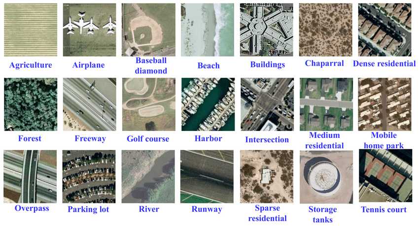
The UC merced dataset is a well known classification dataset.
Classification is a fundamental task in remote sensing data analysis, where the goal is to assign a semantic label to each image, such as 'urban', 'forest', 'agricultural land', etc. The process of assigning labels to an image is known as image-level classification. However, in some cases, a single image might contain multiple different land cover types, such as a forest with a river running through it, or a city with both residential and commercial areas. In these cases, image-level classification becomes more complex and involves assigning multiple labels to a single image. This can be accomplished using a combination of feature extraction and machine learning algorithms to accurately identify the different land cover types. It is important to note that image-level classification should not be confused with pixel-level classification, also known as semantic segmentation. While image-level classification assigns a single label to an entire image, semantic segmentation assigns a label to each individual pixel in an image, resulting in a highly detailed and accurate representation of the land cover types in an image. Read A brief introduction to satellite image classification with neural networks
-
EuroSat-Satellite-CNN-and-ResNet -> Classifying custom image datasets by creating Convolutional Neural Networks and Residual Networks from scratch with PyTorch
-
Land-Cover-Classification-using-Sentinel-2-Dataset -> well written Medium article accompanying this repo but using the EuroSAT dataset
-
Slums mapping from pretrained CNN network on VHR (Pleiades: 0.5m) and MR (Sentinel: 10m) imagery
-
Comparing urban environments using satellite imagery and convolutional neural networks -> includes interesting study of the image embedding features extracted for each image on the Urban Atlas dataset
-
RSI-CB -> A Large Scale Remote Sensing Image Classification Benchmark via Crowdsource Data. See also Remote-sensing-image-classification
-
WaterNet -> a CNN that identifies water in satellite images
-
Road-Network-Classification -> Road network classification model using ResNet-34, road classes organic, gridiron, radial and no pattern
-
SSTN -> Spectral-Spatial Transformer Network for Hyperspectral Image Classification: A FAS Framework
-
SatellitePollutionCNN -> A novel algorithm to predict air pollution levels with state-of-the-art accuracy using deep learning and GoogleMaps satellite images
-
PropertyClassification -> Classifying the type of property given Real Estate, satellite and Street view Images
-
remote-sense-quickstart -> classification on a number of datasets, including with attention visualization
-
IGARSS2020_BWMS -> Band-Wise Multi-Scale CNN Architecture for Remote Sensing Image Scene Classification with a novel CNN architecture for the feature embedding of high-dimensional RS images
-
image.classification.on.EuroSAT -> solution in pure pytorch
-
hurricane_damage -> Post-hurricane structure damage assessment based on aerial imagery
-
ISPRS_S2FL -> Multimodal Remote Sensing Benchmark Datasets for Land Cover Classification with A Shared and Specific Feature Learning Model
-
ensemble_LCLU -> Deep neural network ensembles for remote sensing land cover and land use classification
-
Urban-Analysis-Using-Satellite-Imagery -> classify urban area as planned or unplanned using a combination of segmentation and classification
-
mining-discovery-with-deep-learning -> Mining and Tailings Dam Detection in Satellite Imagery Using Deep Learning
-
sentinel2-deep-learning -> Novel Training Methodologies for Land Classification of Sentinel-2 Imagery
-
Pay-More-Attention -> Remote Sensing Image Scene Classification Based on an Enhanced Attention Module
-
SKAL -> Looking Closer at the Scene: Multiscale Representation Learning for Remote Sensing Image Scene Classification
-
SAFF -> Self-Attention-Based Deep Feature Fusion for Remote Sensing Scene Classification
-
GLNET -> Convolutional Neural Networks Based Remote Sensing Scene Classification under Clear and Cloudy Environments
-
Remote-sensing-image-classification -> transfer learning using pytorch to classify remote sensing data into three classes: aircrafts, ships, none
-
remote_sensing_pretrained_models -> as an alternative to fine tuning on models pretrained on ImageNet, here some CNN are pretrained on the RSD46-WHU & AID datasets
-
OBIC-GCN -> Object-based Classification Framework of Remote Sensing Images with Graph Convolutional Networks
-
aitlas-arena -> An open-source benchmark framework for evaluating state-of-the-art deep learning approaches for image classification in Earth Observation (EO)
-
droughtwatch -> Satellite-based Prediction of Forage Conditions for Livestock in Northern Kenya
-
JSTARS_2020_DPN-HRA -> Deep Prototypical Networks With Hybrid Residual Attention for Hyperspectral Image Classification
-
SIGNA -> Semantic Interleaving Global Channel Attention for Multilabel Remote Sensing Image Classification
-
PBDL -> Patch-Based Discriminative Learning for Remote Sensing Scene Classification
-
EmergencyNet -> identify fire and other emergencies from a drone
-
satellite-deforestation -> Using Satellite Imagery to Identify the Leading Indicators of Deforestation, applied to the Kaggle Challenge Understanding the Amazon from Space
-
RSMLC -> Deep Network Architectures as Feature Extractors for Multi-Label Classification of Remote Sensing Images
-
FireRisk -> A Remote Sensing Dataset for Fire Risk Assessment with Benchmarks Using Supervised and Self-supervised Learning
-
flood_susceptibility_mapping -> Towards urban flood susceptibility mapping using data-driven models in Berlin, Germany
-
Building-detection-and-roof-type-recognition -> A CNN-Based Approach for Automatic Building Detection and Recognition of Roof Types Using a Single Aerial Image
-
SNN4Space -> project which investigates the feasibility of deploying spiking neural networks (SNN) in land cover and land use classification tasks
-
vessel-classification -> classify vessels and identify fishing behavior based on AIS data
-
RSMamba -> Remote Sensing Image Classification with State Space Model
-
BirdSAT -> Cross-View Contrastive Masked Autoencoders for Bird Species Classification and Mapping
-
EGNNA_WND -> Estimating the presence of the West Nile Disease employing Graph Neural network
-
cyfi -> Estimate cyanobacteria density based on Sentinel-2 satellite imagery
-
3DGAN-ViT -> A deep learning framework based on generative adversarial networks and vision transformer for complex wetland classification
-
automatic_solar_pv_detection -> Automatic Solar PV Panel Image Classification with Deep Neural Network Transfer Learning
-
U-netR -> Land Use Land Cover Classification with U-Net: Advantages of Combining Sentinel-1 and Sentinel-2 Imagery paper
-
nshaud/DeepNetsForEO -> Deep networks for Earth Observation with PyTorch implementations of state-of-the-art architectures for remote sensing image classification
-
sentinel-landslide-cls -> Classification for Landslide Detection, using Sentinel-1 and Sentinel-2 data.
-
Infra-Bench CLS -> code for paper: Infra-Bench CLS: A Global, Open-Source Benchmark for Critical Infrastructure Classification with Earth Observation Foundation Models
-
Detecting old-growth forests -> code for paper: Geospatial embeddings detect old-growth forests but buffered spatial validation narrows their advantage over Sentinel features
Segmentation

(left) a satellite image and (right) the semantic classes in the image.
Image segmentation is a crucial step in image analysis and computer vision, with the goal of dividing an image into semantically meaningful segments or regions. The process of image segmentation assigns a class label to each pixel in an image, effectively transforming an image from a 2D grid of pixels into a 2D grid of pixels with assigned class labels. One common application of image segmentation is road or building segmentation, where the goal is to identify and separate roads and buildings from other features within an image. To accomplish this task, single class models are often trained to differentiate between roads and background, or buildings and background. These models are designed to recognize specific features, such as color, texture, and shape, that are characteristic of roads or buildings, and use this information to assign class labels to the pixels in an image. Another common application of image segmentation is land use or crop type classification, where the goal is to identify and map different land cover types within an image. In this case, multi-class models are typically used to recognize and differentiate between multiple classes within an image, such as forests, urban areas, and agricultural land. These models are capable of recognizing complex relationships between different land cover types, allowing for a more comprehensive understanding of the image content. Read A brief introduction to satellite image segmentation with neural networks. Note that many articles which refer to 'hyperspectral land classification' are often actually describing semantic segmentation.
Segmentation - Land use & land cover
-
CDL-Segmentation -> Deep Learning Based Land Cover and Crop Type Classification: A Comparative Study. Compares UNet, SegNet & DeepLabv3+
-
LoveDA -> A Remote Sensing Land-Cover Dataset for Domain Adaptive Semantic Segmentation
-
CNN_Enhanced_GCN -> CNN-Enhanced Graph Convolutional Network With Pixel- and Superpixel-Level Feature Fusion for Hyperspectral Image Classification
-
LULCMapping-WV3images-CORINE-DLMethods -> Land Use and Land Cover Mapping Using Deep Learning Based Segmentation Approaches and VHR Worldview-3 Images
-
MCANet -> A joint semantic segmentation framework of optical and SAR images for land use classification. Uses WHU-OPT-SAR-dataset
-
land-cover -> Model Generalization in Deep Learning Applications for Land Cover Mapping
-
generalizablersc -> Cross-dataset Learning for Generalizable Land Use Scene Classification
-
SSLTransformerRS -> Self-supervised Vision Transformers for Land-cover Segmentation and Classification
-
LULCMapping-WV3images-CORINE-DLMethods -> Land Use and Land Cover Mapping Using Deep Learning Based Segmentation Approaches and VHR Worldview-3 Images
-
DCSA-Net -> Dynamic Convolution Self-Attention Network for Land-Cover Classification in VHR Remote-Sensing Images
-
CHeGCN-CNN_enhanced_Heterogeneous_Graph -> CNN-Enhanced Heterogeneous Graph Convolutional Network: Inferring Land Use from Land Cover with a Case Study of Park Segmentation
-
TCSVT_2022_DGSSC -> DGSSC: A Deep Generative Spectral-Spatial Classifier for Imbalanced Hyperspectral Imagery
-
DeepForest-Wetland-Paper -> Deep Forest classifier for wetland mapping using the combination of Sentinel-1 and Sentinel-2 data, GIScience & Remote Sensing
-
Wetland_UNet -> UNet models that can delineate wetlands using remote sensing data input including bands from Sentinel-2 LiDAR and geomorphons. By the Conservation Innovation Center of Chesapeake Conservancy and Defenders of Wildlife
-
DPA -> DPA is an unsupervised domain adaptation (UDA) method applied to different satellite images for large-scale land cover mapping.
-
dynamicworld -> Dynamic World, global 10 m land use land cover mapping from Google. dynamic_world_pytorch is a pytorch implementation.
-
spada -> Land Cover Segmentation with Sparse Annotations from Sentinel-2 Imagery
-
M3SPADA -> Multi-Sensor Temporal Unsupervised Domain Adaptation for Land Cover Mapping with spatial pseudo labelling and adversarial learning
-
GLNet -> Collaborative Global-Local Networks for Memory-Efficient Segmentation of Ultra-High Resolution Images
-
LoveNAS -> LoveNAS: Towards Multi-Scene Land-Cover Mapping via Hierarchical Searching Adaptive Network
-
FLAIR-2 challenge -> Semantic segmentation and domain adaptation challenge proposed by the French National Institute of Geographical and Forest Information (IGN)
-
igarss-spada -> Dataset and code for the paper Land Cover Segmentation with Sparse Annotations from Sentinel-2 Imagery IGARSS 2023
-
cnn-land-cover-eco -> Multi-stage semantic segmentation of land cover in the Peak District using high-resolution RGB aerial imagery
-
LALE -> a lightweight hybrid ConvMixer-transformer architecture for efficient land-cover segmentation in remote sensing imagery
Segmentation - Vegetation, deforestation, crops & field boundaries
Note that deforestation detection may be treated as a segmentation task or a change detection task
-
DetecTree -> Tree detection from aerial imagery in Python, a LightGBM classifier of tree/non-tree pixels from aerial imagery
-
kenya-crop-mask -> Annual and in-season crop mapping in Kenya - LSTM classifier to classify pixels as containing crop or not, and a multi-spectral forecaster that provides a 12 month time series given a partial input. Dataset downloaded from GEE and pytorch lightning used for training
-
Find sports fields using Mask R-CNN and overlay on open-street-map
-
DeepSatModels -> Context-self contrastive pretraining for crop type semantic segmentation
-
DeepTreeAttention -> Implementation of Hang et al. 2020 "Hyperspectral Image Classification with Attention Aided CNNs" for tree species prediction
-
Crop-Classification -> crop classification using multi temporal satellite images
-
crop-mask -> End-to-end workflow for generating high resolution cropland maps, uses GEE & LSTM model
-
DeepCropMapping -> A multi-temporal deep learning approach with improved spatial generalizability for dynamic corn and soybean mapping, uses LSTM
-
ResUnet-a -> a deep learning framework for semantic segmentation of remotely sensed data
-
DSD_paper_2020 -> Crop Type Classification based on Machine Learning with Multitemporal Sentinel-1 Data
-
MR-DNN -> extract rice field from Landsat 8 satellite imagery
-
deep_learning_forest_monitoring -> Forest mapping and monitoring of the African continent using Sentinel-2 data and deep learning
-
global-cropland-mapping -> global multi-temporal cropland mapping
-
Landuse_DL -> delineate landforms due to the thawing of ice-rich permafrost
-
canopy -> A Convolutional Neural Network Classifier Identifies Tree Species in Mixed-Conifer Forest from Hyperspectral Imagery
-
forest_change_detection -> forest change segmentation with time-dependent models, including Siamese, UNet-LSTM, UNet-diff, UNet3D models
-
cultionet -> segmentation of cultivated land, built on PyTorch Geometric and PyTorch Lightning
-
sentinel-tree-cover -> A global method to identify trees outside of closed-canopy forests with medium-resolution satellite imagery
-
crop-type-detection-ICLR-2020 -> Winning Solutions from Crop Type Detection Competition at CV4A workshop, ICLR 2020
-
S4A-Models -> Various experiments on the Sen4AgriNet dataset
-
attention-mechanism-unet -> An attention-based U-Net for detecting deforestation within satellite sensor imagery
-
SummerCrop_Deeplearning -> A Transferable Learning Classification Model and Carbon Sequestration Estimation of Crops in Farmland Ecosystem
-
DeepForest is a python package for training and predicting individual tree crowns from airborne RGB imagery
-
Official repository for the "Identifying trees on satellite images" challenge from Omdena
-
PTDM -> Pomelo Tree Detection Method Based on Attention Mechanism and Cross-Layer Feature Fusion
-
urban-tree-detection -> Individual Tree Detection in Large-Scale Urban Environments using High-Resolution Multispectral Imagery. With dataset
-
BioMassters_baseline -> a basic pytorch lightning baseline using a UNet for getting started with the BioMassters challenge (biomass estimation)
-
Biomassters winners -> top 3 solutions
-
kbrodt biomassters solution -> 1st place solution
-
biomass-estimation -> from Azavea, applied to Sentinel 1 & 2
-
3DUNetGSFormer -> A deep learning pipeline for complex wetland mapping using generative adversarial networks and Swin transformer
-
SEANet_torch -> Using a semantic edge-aware multi-task neural network to delineate agricultural parcels from remote sensing images
-
arborizer -> Tree crowns segmentation and classification
-
ReUse -> REgressive Unet for Carbon Storage and Above-Ground Biomass Estimation
-
unet-sentinel -> UNet to handle Sentinel-1 SAR images to identify deforestation
-
MaskedSST -> Masked Vision Transformers for Hyperspectral Image Classification
-
UNet-defmapping -> master's thesis using UNet to map deforestation using Sentinel-2 Level 2A images, applied to Amazon and Atlantic Rainforest dataset
-
cvpr-multiearth-deforestation-segmentation -> multimodal Unet entry to the CVPR Multiearth 2023 deforestation challenge
-
TransUNetplus2 -> TransU-Net++: Rethinking attention gated TransU-Net for deforestation mapping. Uses the Amazon and Atlantic forest dataset
-
A high-resolution canopy height model of the Earth -> A high-resolution canopy height model of the Earth
-
Radiant Earth Spot the Crop Challenge -> Winning models from the Radiant Earth Spot the Crop Challenge, uses a time-series of Sentinel-2 multispectral data to classify crops in the Western Cape of South Africa. Another solution
-
transfer-field-delineation -> Multi-Region Transfer Learning for Segmentation of Crop Field Boundaries in Satellite Images with Limited Labels
-
crop-field-segmentation-ukan -> KANs and Sentinel for Effective and Explainable Crop Field Segmentation
-
mowing-detection -> Automatic detection of mowing and grazing from Sentinel images
-
PTAViT3D and PTAViT3DCA -> Tackling fluffy clouds: field boundaries detection using time series of S2 and/or S1 imagery
-
ai4boundaries -> a Python package that facilitates download of the AI4boundaries data set
-
Nasa_harvest_field_boundary_competition -> Nasa Harvest Rwanda Field Boundary Detection Challenge Tutorial
-
nasa_harvest_boundary_detection_challenge -> the 4th place solution for NASA Harvest Field Boundary Detection Challenge on Zindi.
-
rainforest-segmentation -> Identifying and tracking deforestation in the Amazon Rainforest using state-of-the-art deep learning models and multispectral satellite imagery.
-
Delineate Anything: Resolution-Agnostic Field Boundary Delineation on Satellite Imagery
-
Semantic_segmentation_for_LCLUC -> Semantic Segmentation for Simultaneous Crop and Land Cover Land Use Classification Using Multi-Temporal Landsat Imagery
-
boundary-sam -> parcel boundary delineation using SAM, image embeddings and detail enhancement filters
-
TOFMapper -> a semantic segmentation tool for mapping and classifying Trees outside Forest in high resolution aerial images
-
Mask-PSTIN -> Improving crop type mapping by integrating LSTM with temporal random masking and pixel-set spatial information
-
paddy_identification -> Paddy Field Instance Segmentation using Multi-Temporal SAR Time Series
-
CropSight -> towards a large-scale operational framework for object-based crop type ground truth retrieval using street view and PlanetScope satellite imagery
-
ftw-prue -> PRUE: A Practical Recipe for Field Boundary Segmentation at Scale.
-
agribound -> An AI-powered field boundary delineation toolkit combining satellite foundation models, embeddings, and global training data for accurate agricultural parcel/field boundary mapping.
-
s2-forest-browning-monitoring -> Monitoring forest browning using Sentinel-2 imagery.
-
LacunaLabels -> A region-wide, multi-year set of crop field boundary labels for Africa.
-
Pseudo-fields -> Generating pseudo labels for satellite-based crop field delineatio.
-
JEDI -> code for paper: JEDI: JEPA-to-Edge Distillation for Efficient Cropland Segmentation from Satellite Imagery
-
NAIP Farmland ResSAM -> code for paper: Farmland Extent and Visible Boundary Mapping from 1 m NAIP Imagery Using Residual U-Net and Text-Prompted SAM 3 Refinement
-
Fields of the Planet -> code and dataset for paper: Fields of the Planet: Field Boundary Mapping Beyond 10m
Segmentation - Water, coastlines, rivers & floods
-
sat-water -> Semantic segmentation of water bodies in satellite imagery, producing pixel-wise water masks from remote sensing images using a U-Net–style deep learning pipeline (data preparation, training, inference, and evaluation).
-
Houston_flooding -> labeling each pixel as either flooded or not using data from Hurricane Harvey. Dataset consisted of pre and post flood images, and a ground truth floodwater mask was created using unsupervised clustering (with DBScan) of image pixels with human cluster verification/adjustment
-
ml4floods -> An ecosystem of data, models and code pipelines to tackle flooding with ML
-
floodmaps -> an end-to-end pipeline and segmentation models for flood-water detection using Sentinel-1 SAR and Sentinel-2 multispectral imagery
-
1st place solution for STAC Overflow: Map Floodwater from Radar Imagery hosted by Microsoft AI for Earth -> combines Unet with Catboostclassifier, taking their maxima, not the average
-
hydra-floods -> an open source Python application for downloading, processing, and delivering surface water maps derived from remote sensing data
-
CoastSat -> tool for mapping coastlines which has an extension CoastSeg using segmentation models
-
deepwatermap -> a deep model that segments water on multispectral images
-
rivamap -> an automated river analysis and mapping engine
-
deep-water -> track changes in water level
-
WatNet -> A deep ConvNet for surface water mapping based on Sentinel-2 image, uses the Earth Surface Water Dataset
-
floatingobjects -> TOWARDS DETECTING FLOATING OBJECTS ON A GLOBAL SCALE WITHLEARNED SPATIAL FEATURES USING SENTINEL 2. Uses U-Net & pytorch
-
SpaceNet8 -> baseline Unet solution to detect flooded roads and buildings
-
dlsim -> Breaking the Limits of Remote Sensing by Simulation and Deep Learning for Flood and Debris Flow Mapping
-
Water-HRNet -> HRNet trained on Sentinel 2
-
semantic segmentation model to identify newly developed or flooded land using NAIP imagery provided by the Chesapeake Conservancy, training on MS Azure
-
BandNet -> Analysis and application of multispectral data for water segmentation using machine learning. Uses Sentinel-2 data
-
mmflood -> MMFlood: A Multimodal Dataset for Flood Delineation From Satellite Imagery (Sentinel 1 SAR)
-
Urban_flooding -> Towards transferable data-driven models to predict urban pluvial flood water depth in Berlin, Germany
-
MECNet -> Rich CNN features for water-body segmentation from very high resolution aerial and satellite imagery
-
SWRNET -> A Deep Learning Approach for Small Surface Water Area Recognition Onboard Satellite
-
elwha-segmentation -> fine-tuning Meta's Segment Anything (SAM) for bird's eye view river pixel segmentation
-
RiverSnap -> code for paper: A Comparative Performance Analysis of Popular Deep Learning Models and Segment Anything Model (SAM) for River Water Segmentation in Close-Range Remote Sensing Imagery
-
SAR-water-segmentation -> Deep Learning based Water Segmentation Using KOMPSAT-5 SAR Images
-
TerraMind-Flood -> DEM-Enhanced Flood Detection with Physics-Aware Learning, applied to Sen1Flood11
-
Prithvi-CAFE -> Transformer-based global reasoning (Prithvi-EO-2.0) with CNN-based local spatial sensitivity, enabling high-resolution, reliable flood inundation mapping across multi-channel/sensor inputs, applied to Sen1Flood11
-
SMAGNet -> A Spatially Masked Adaptive Gated Network for Multimodal Post-Flood Water Extent Mapping using SAR and Incomplete Multispectral Data. Uses c2smsfloods dataset
-
OmniWaterMask-training -> Training code for the deep learning model used in OmniWaterMask - a Python library for detecting water bodies in satellite and aerial imagery.
-
utae-water-segmentation -> UTAE-PAPS model for water/land segmentation using Sentinel-1 and Sentinel-2 data with IBM Granite flood detection dataset
Segmentation - Fire, smoke & burn areas
-
SatelliteVu-AWS-Disaster-Response-Hackathon -> fire spread prediction using classical ML & deep learning
-
A Practical Method for High-Resolution Burned Area Monitoring Using Sentinel-2 and VIIRS
-
IndustrialSmokePlumeDetection -> using Sentinel-2 & a modified ResNet-50
-
burned-area-detection -> uses Sentinel-2
-
rescue -> Attention to fires: multi-channel deep-learning models for wildfire severity prediction
-
smoke_segmentation -> Segmenting smoke plumes and predicting density from GOES imagery
-
wildfire-detection -> Using Vision Transformers for enhanced wildfire detection in satellite images
-
Burned_Area_Detection -> Detecting Burned Areas with Sentinel-2 data
-
burned-area-baseline -> baseline unet model accompanying the Satellite Burned Area Dataset (Sentinel 1 & 2)
-
burned-area-seg -> Burned area segmentation from Sentinel-2 using multi-task learning
-
chabud2023 -> Change detection for Burned area Delineation (ChaBuD) ECML/PKDD 2023 challenge
-
Post Wildfire Burnt-up Detection using Siamese-UNet -> on Chadbud dataset
-
vit-burned-detection -> Vision transformers in burned area delineation
-
ai4good25-wildfire -> AI4GOOD Class Fall 2025 : Wildfire spread prediction project
-
wildfire-lora-gfm -> adapting large Earth-Observation foundation models (Prithvi-v2, TerraMind, DINOv3) using LoRA, to detect wildfire burned areas from bi-temporal (pre-fire / post-fire) Sentinel-2 imagery.
Segmentation - Landslides
-
landslide-sar-unet -> Deep Learning for Rapid Landslide Detection using Synthetic Aperture Radar (SAR) Datacubes
-
landslide-mapping-with-cnn -> A new strategy to map landslides with a generalized convolutional neural network
-
Landslide-mapping-on-SAR-data-by-Attention-U-Net -> Rapid Mapping of landslide on SAR data by Attention U-net
-
SAR-landslide-detection-pretraining -> SAR-based landslide classification pretraining leads to better segmentation
-
Landslide mapping from Sentinel-2 imagery through change detection
-
landslide4sense-solution -> solution of Tek Kshetri
-
DiGATe-UNet-LandSlide-Segmentation -> Lightweight Dual-Stream Framework for Landslide Segmentation
-
Erosion-detection -> using Sentinel-2 to detect erosion
Segmentation - Glaciers
-
HED-UNet -> a model for simultaneous semantic segmentation and edge detection, examples provided are glacier fronts and building footprints using the Inria Aerial Image Labeling dataset
-
glacier_mapping -> Mapping glaciers in the Hindu Kush Himalaya, Landsat 7 images, Shapefile labels of the glaciers, Unet with dropout
-
Antarctic-fracture-detection -> uses UNet with the MODIS Mosaic of Antarctica to detect surface fractures
-
sentinel_lakeice -> Lake Ice Detection from Sentinel-1 SAR with Deep Learning
-
MCD-Net -> a lightweight deep learning framework for optical-only moraine segmentation
-
landslides_segmentation -> super-resolution and segmentation of multispectral Sentinel-2 satellite imagery, applied to landslide monitoring in Italian municipalities.
-
GlacierCastAI -> forecasts glacier boundary retreat from Landsat time series, ERA5 climate data and Copernicus DEM terrain features using a multimodal ConvLSTM model
Segmentation - methane
-
Methane-detection-from-hyperspectral-imagery -> Deep Remote Sensing Methods for Methane Detection in Overhead Hyperspectral Imagery
-
methane-emission-project -> Classification CNNs was combined in an ensemble approach with traditional methods on tabular data
-
CH4Net -> A fast, simple model for detection of methane plumes using sentinel-2
-
STARCOP: Semantic Segmentation of Methane Plumes with Hyperspectral Machine Learning models
-
Project-Eucalyptus -> pipelines for satellite-based methane detection. Includes trained segmentation models, a synthetic plume generator, and benchmarking tools for Sentinel-2, Landsat 8/9, and EMIT.
-
MethaneFuse -> code for paper: MethaneFuse: Learning from Multi-Sensor Satellite Observations for Methane Plume Detection
Segmentation - Other environmental
-
Detection of Open Landfills -> uses Sentinel-2 to detect large changes in the Normalized Burn Ratio (NBR)
-
sea_ice_remote_sensing -> Sea Ice Concentration classification
-
EddyNet -> A Deep Neural Network For Pixel-Wise Classification of Oceanic Eddies
-
schisto-vegetation -> Deep Learning Segmentation of Satellite Imagery Identifies Aquatic Vegetation Associated with Snail Intermediate Hosts of Schistosomiasis in Senegal, Africa
-
Earthformer -> Exploring space-time transformers for earth system forecasting
-
weather4cast-2022 -> Unet-3D baseline model for Weather4cast Rain Movie Prediction competition
-
WeatherFusionNet -> Predicting Precipitation from Satellite Data. weather4cast-2022 1st place solution
-
marinedebrisdetector -> Large-scale Detection of Marine Debris in Coastal Areas with Sentinel-2
-
kaggle-identify-contrails-4th -> 4th place Solution, Google Research - Identify Contrails to Reduce Global Warming
-
MineSegSAT -> An automated system to evaluate mining disturbed area extents from Sentinel-2 imagery
-
asos -> Recognizing protected and anthropogenic patterns in landscapes using interpretable machine learning and satellite imagery
-
SinkSAM -> Knowledge-Driven Self-Supervised Sinkhole Segmentation Using Topographic Priors and Segment Anything Model
-
SENSE -> Satellite-based ENergy Synthesis for Sustainable Environment
Segmentation - Roads & sidewalks
Extracting roads is challenging due to the occlusions caused by other objects and the complex traffic environment
-
ChesapeakeRSC -> segmentation to extract roads from the background but are additionally evaluated by how they perform on the "Tree Canopy Over Road" class
-
ML_EPFL_Project_2 -> U-Net in Pytorch to perform semantic segmentation of roads on satellite images
-
Winning Solutions from SpaceNet Road Detection and Routing Challenge
-
awesome-deep-map -> A curated list of resources dedicated to deep learning / computer vision algorithms for mapping. The mapping problems include road network inference, building footprint extraction, etc.
-
RoadTracer: Automatic Extraction of Road Networks from Aerial Images -> uses an iterative search process guided by a CNN-based decision function to derive the road network graph directly from the output of the CNN
-
road_detection_mtl -> Road Detection using a multi-task Learning technique to improve the performance of the road detection task by incorporating prior knowledge constraints, uses the SpaceNet Roads Dataset
-
road_connectivity -> Improved Road Connectivity by Joint Learning of Orientation and Segmentation (CVPR2019)
-
SPIN_RoadMapper -> Extracting Roads from Aerial Images via Spatial and Interaction Space Graph Reasoning for Autonomous Driving
-
road_extraction_remote_sensing -> pytorch implementation, CVPR2018 DeepGlobe Road Extraction Challenge submission. See also DeepGlobe-Road-Extraction-Challenge
-
CoANet -> Connectivity Attention Network for Road Extraction From Satellite Imagery. The CoA module incorporates graphical information to ensure the connectivity of roads are better preserved
-
Satellite Imagery Road Segmentation -> intro article on Medium using the kaggle Massachusetts Roads Dataset
-
Label-Pixels -> for semantic segmentation of roads and other features
-
Satellite-image-road-extraction -> Road Extraction by Deep Residual U-Net
-
road_building_extraction -> Pytorch implementation of U-Net architecture for road and building extraction
-
RCFSNet -> Road Extraction From Satellite Imagery by Road Context and Full-Stage Feature
-
SGCN -> Split Depth-Wise Separable Graph-Convolution Network for Road Extraction in Complex Environments From High-Resolution Remote-Sensing Images
-
ASPN -> Road Segmentation for Remote Sensing Images using Adversarial Spatial Pyramid Networks
-
cresi -> Road network extraction from satellite imagery, with speed and travel time estimates
-
D-LinkNet -> LinkNet with Pretrained Encoder and Dilated Convolution for High Resolution Satellite Imagery Road Extraction
-
Sat2Graph -> Road Graph Extraction through Graph-Tensor Encoding
-
RoadTracer-M -> Road Network Extraction from Satellite Images Using CNN Based Segmentation and Tracing
-
ScRoadExtractor -> Scribble-based Weakly Supervised Deep Learning for Road Surface Extraction from Remote Sensing Images
-
RoadDA -> Stagewise Unsupervised Domain Adaptation with Adversarial Self-Training for Road Segmentation of Remote Sensing Images
-
DeepSegmentor -> A Pytorch implementation of DeepCrack and RoadNet projects
-
Cascaded Residual Attention Enhanced Road Extraction from Remote Sensing Images
-
NL-LinkNet -> Toward Lighter but More Accurate Road Extraction with Non-Local Operations
-
IRSR-net -> Lightweight Remote Sensing Road Detection Network
-
hironex -> A python tool for automatic, fully unsupervised extraction of historical road networks from historical maps
-
Road_detection_model -> Mapping Roads in the Brazilian Amazon with Artificial Intelligence and Sentinel-2
-
DTnet -> Road detection via a dual-task network based on cross-layer graph fusion modules
-
Automatic-Road-Extraction-from-Historical-Maps-using-Deep-Learning-Techniques -> Automatic Road Extraction from Historical Maps using Deep Learning Techniques
-
Istanbul_Dataset -> segmentation on the Istanbul, Inria and Massachusetts datasets
-
D-LinkNet -> 1st place solution in DeepGlobe Road Extraction Challenge
-
PaRK-Detect -> PaRK-Detect: Towards Efficient Multi-Task Satellite Imagery Road Extraction via Patch-Wise Keypoints Detection
-
tile2net -> Mapping the walk: A scalable computer vision approach for generating sidewalk network datasets from aerial imagery
-
sam_road -> Segment Anything Model (SAM) for large-scale, vectorized road network extraction from aerial imagery.
-
LRDNet -> A Lightweight Road Detection Algorithm Based on Multiscale Convolutional Attention Network and Coupled Decoder Head
-
Fine–Grained Extraction of Road Networks via Joint Learning of Connectivity and Segmentation -> uses SpaceNet 3 dataset
-
Satellite-Image-Road-Segmentation -> Graph Reasoned Multi-Scale Road Segmentation in Remote Sensing Imagery
-
PathFinder -> A Foundation Model for Road Mapping in Support of United Nations Humanitarian Affairs
Segmentation - Buildings & rooftops
-
Road and Building Semantic Segmentation in Satellite Imagery uses U-Net on the Massachusetts Roads Dataset & keras
-
find unauthorized constructions using aerial photography -> Dataset creation
-
SRBuildSeg -> Making low-resolution satellite images reborn: a deep learning approach for super-resolution building extraction
-
automated-building-detection -> Input: very-high-resolution (<= 0.5 m/pixel) RGB satellite images. Output: buildings in vector format (geojson), to be used in digital map products. Built on top of robosat and robosat.pink.
-
JointNet-A-Common-Neural-Network-for-Road-and-Building-Extraction
-
Mapping Africa’s Buildings with Satellite Imagery: Google AI blog post. See the open-buildings dataset
-
nz_convnet -> A U-net based ConvNet for New Zealand imagery to classify building outlines
-
polycnn -> End-to-End Learning of Polygons for Remote Sensing Image Classification
-
spacenet_building_detection solution by motokimura using Unet
-
Semantic-segmentation repo by fuweifu-vtoo -> uses pytorch and the Massachusetts Buildings & Roads Datasets
-
Extracting buildings and roads from AWS Open Data using Amazon SageMaker -> With repo
-
TF-SegNet -> AirNet is a segmentation network based on SegNet, but with some modifications
-
rgb-footprint-extract -> a Semantic Segmentation Network for Urban-Scale Building Footprint Extraction Using RGB Satellite Imagery, DeepLavV3+ module with a Dilated ResNet C42 backbone
-
SpaceNetExploration -> A sample project demonstrating how to extract building footprints from satellite images using a semantic segmentation model. Data from the SpaceNet Challenge
-
Rooftop-Instance-Segmentation -> VGG-16, Instance Segmentation, uses the Airs dataset
-
solar-farms-mapping -> An Artificial Intelligence Dataset for Solar Energy Locations in India
-
poultry-cafos -> This repo contains code for detecting poultry barns from high-resolution aerial imagery and an accompanying dataset of predicted barns over the United States
-
ssai-cnn -> This is an implementation of Volodymyr Mnih's dissertation methods on his Massachusetts road & building dataset
-
Remote-sensing-building-extraction-to-3D-model-using-Paddle-and-Grasshopper
-
segmentation-enhanced-resunet -> Urban building extraction in Daejeon region using Modified Residual U-Net (Modified ResUnet) and applying post-processing
-
GRSL_BFE_MA -> Deep Learning-based Building Footprint Extraction with Missing Annotations using a novel loss function
-
FER-CNN -> Detection, Classification and Boundary Regularization of Buildings in Satellite Imagery Using Faster Edge Region Convolutional Neural Networks
-
Vector-Map-Generation-from-Aerial-Imagery-using-Deep-Learning-GeoSpatial-UNET -> applied to geo-referenced images which are very large size > 10k x 10k pixels
-
building-footprint-segmentation -> pip installable library to train building footprint segmentation on satellite and aerial imagery, applied to Massachusetts Buildings Dataset and Inria Aerial Image Labeling Dataset
-
FCNN-example -> overfit to a given single image to detect houses
-
SAT2LOD2 -> an open-source, python-based GUI-enabled software that takes the satellite images as inputs and returns LoD2 building models as outputs
-
SatFootprint -> building segmentation on the Spacenet 7 dataset
-
Building-Detection -> Raster Vision experiment to train a model to detect buildings from satellite imagery in three cities in Latin America
-
Multi-building-tracker -> Multi-target building tracker for satellite images using deep learning
-
Boundary Enhancement Semantic Segmentation for Building Extraction
-
LGPNet-BCD -> Building Change Detection for VHR Remote Sensing Images via Local-Global Pyramid Network and Cross-Task Transfer Learning Strategy
-
MTL_homoscedastic_SRB -> A Multi-Task Deep Learning Framework for Building Footprint Segmentation
-
FDANet -> Full-Level Domain Adaptation for Building Extraction in Very-High-Resolution Optical Remote-Sensing Images
-
CBRNet -> A Coarse-to-fine Boundary Refinement Network for Building Extraction from Remote Sensing Imagery
-
ASLNet -> Adversarial Shape Learning for Building Extraction in VHR Remote Sensing Images
-
BRRNet -> A Fully Convolutional Neural Network for Automatic Building Extraction From High-Resolution Remote Sensing Images
-
Multi-Scale-Filtering-Building-Index -> A Multi - Scale Filtering Building Index for Building Extraction in Very High - Resolution Satellite Imagery
-
Models for Remote Sensing -> long list of unets etc applied to building detection
-
boundary_loss_for_remote_sensing -> Boundary Loss for Remote Sensing Imagery Semantic Segmentation
-
Open Cities AI Challenge -> Segmenting Buildings for Disaster Resilience. Winning solutions on Github
-
MAPNet -> Multi Attending Path Neural Network for Building Footprint Extraction from Remote Sensed Imagery
-
dual-hrnet -> localizing buildings and classifying their damage level
-
ESFNet -> Efficient Network for Building Extraction from High-Resolution Aerial Images
-
CVCMFFNet -> Complex-Valued Convolutional and Multifeature Fusion Network for Building Semantic Segmentation of InSAR Images
-
STEB-UNet -> A Swin Transformer-Based Encoding Booster Integrated in U-Shaped Network for Building Extraction
-
dfc2020_baseline -> Baseline solution for the IEEE GRSS Data Fusion Contest 2020. Predict land cover labels from Sentinel-1 and Sentinel-2 imagery
-
Fusing multiple segmentation models based on different datasets into a single edge-deployable model -> roof, car & road segmentation
-
ground-truth-gan-segmentation -> use Pix2Pix to segment the footprint of a building. The dataset used is AIRS
-
UNICEF-Giga_Sudan -> Detecting school lots from satellite imagery in Southern Sudan using a UNET segmentation model
-
building_footprint_extraction -> The project retrieves satellite imagery from Google and performs building footprint extraction using a U-Net.
-
projectRegularization -> Regularization of building boundaries in satellite images using adversarial and regularized losses
-
PolyWorldPretrainedNetwork -> Polygonal Building Extraction with Graph Neural Networks in Satellite Images
-
dl_image_segmentation -> Uncertainty-Aware Interpretable Deep Learning for Slum Mapping and Monitoring. Uses SHAP
-
UBC-dataset -> a dataset for building detection and classification from very high-resolution satellite imagery with the focus on object-level interpretation of individual buildings
-
UNetFormer -> A UNet-like transformer for efficient semantic segmentation of remote sensing urban scene imagery
-
BES-Net -> Boundary Enhancing Semantic Context Network for High-Resolution Image Semantic Segmentation. Applied to Vaihingen and Potsdam datasets
-
CVNet -> Contour Vibration Network for Building Extraction
-
CFENet -> A Context Feature Enhancement Network for Building Extraction from High-Resolution Remote Sensing Imagery
-
HiSup -> Accurate Polygonal Mapping of Buildings in Satellite Imagery
-
BuildingExtraction -> Building Extraction from Remote Sensing Images with Sparse Token Transformers
-
CrossGeoNet -> A Framework for Building Footprint Generation of Label-Scarce Geographical Regions
-
AFM_building -> Building Footprint Generation Through Convolutional Neural Networks With Attraction Field Representation
-
RAMP (Replicable AI for MicroPlanning) -> building detection in low and middle income countries
-
Building-instance-segmentation -> Multi-Modal Feature Fusion Network with Adaptive Center Point Detector for Building Instance Extraction
-
CGSANet -> A Contour-Guided and Local Structure-Aware Encoder–Decoder Network for Accurate Building Extraction From Very High-Resolution Remote Sensing Imagery
-
building-footprints-update -> Learning Color Distributions from Bitemporal Remote Sensing Images to Update Existing Building Footprints
-
RAMP -> model and buildings dataset to support a wide variety of humanitarian use cases
-
Thesis_Semantic_Image_Segmentation_on_Satellite_Imagery_using_UNets -> This master thesis aims to perform semantic segmentation of buildings on satellite images from the SpaceNet challenge 1 dataset using the U-Net architecture
-
HD-Net -> High-resolution decoupled network for building footprint extraction via deeply supervised body and boundary decomposition
-
RoofSense -> A novel deep learning solution for the automatic roofing material classification of the Dutch building stock using aerial imagery and laser scanning data fusion
-
IBS-AQSNet -> Enhanced Automated Quality Assessment Network for Interactive Building Segmentation in High-Resolution Remote Sensing Imagery
-
DeepMAO -> Deep Multi-scale Aware Overcomplete Network for Building Segmentation in Satellite Imagery
-
CMGFNet-Building_Extraction -> Deep Learning Code for Building Extraction from very high resolution (VHR) remote sensing images
-
Global Collinearity-aware Polygonizer for Polygonal Building Mapping in Remote Sensing
-
Building Segmentation on LR-HR-SR Satellite Imagery -> perform building delineation on different types of satellite imagery: Low-Resolution (LR), High-Resolution (HR), and Super-Resolution (SR). The goal is to compare the performance of segmentation models across these varying resolutions.
-
UrbanGraphSAGE -> Graph Neural Network (GraphSAGE) for urban building footprint extraction from Sentinel-2 satellite imagery
-
terratorch-building-segmentation -> Fine-tuning Geospatial Foundation Models (Prithvi, TerraMind) for building footprint segmentation from Sentinel-2 using TerraTorch — Algiers case study
-
MRPolyBuild -> code for paper: Rethinking Resolution: Large-Scale Polygonal Building Detection Using Medium-Resolution (3-5m) Satellite Data
Segmentation - Solar panels
-
Deep-Learning-for-Solar-Panel-Recognition -> using both object detection with Yolov5 and Unet segmentation
-
DeepSolar -> A Machine Learning Framework to Efficiently Construct a Solar Deployment Database in the United States. Dataset on kaggle, actually used a CNN for classification and segmentation is obtained by applying a threshold to the activation map. Original code is tf1 but tf2/kers and a pytorch implementation are available. Also checkout [Visualizations and in-depth analysis .. of the factors that can explain the adoption of solar energy in .. Virginia]
-
hyperion_solar_net -> trained classificaton & segmentation models on RGB imagery from Google Maps
-
3D-PV-Locator -> Large-scale detection of rooftop-mounted photovoltaic systems in 3D
-
PV_Pipeline -> DeepSolar for Germany
-
solar-panels-detection -> using SegNet, Fast SCNN & ResNet
-
predict_pv_yield -> Using optical flow & machine learning to predict PV yield
-
Large-scale-solar-plant-monitoring -> Remote Sensing for Monitoring of Photovoltaic Power Plants in Brazil Using Deep Semantic Segmentation
-
Panel-Segmentation -> Determine the presence of a solar array in the satellite image (boolean True/False), using a VGG16 classification model
-
Roofpedia -> an open registry of green roofs and solar roofs across the globe identified by Roofpedia through deep learning
-
Predicting the Solar Potential of Rooftops using Image Segmentation and Structured Data Medium article, using 20cm imagery & Unet
-
remote-sensing-solar-pv -> A repository for sharing progress on the automated detection of solar PV arrays in sentinel-2 remote sensing imagery
-
solar-panel-segmentation) -> Finding solar panels using USGS satellite imagery
-
solar_plant_detection -> boundary extraction of Photovoltaic (PV) plants using Mask RCNN and Amir dataset
-
SolarDetection -> unet on satellite image from the USA and France
-
adopptrs -> Automatic Detection Of Photovoltaic Panels Through Remote Sensing using unet & pytorch
-
solar-panel-locator -> the number of solar panel pixels was only ~0.2% of the total pixels in the dataset, so solar panel data was upsampled to account for the class imbalance
-
projects-solar-panel-detection -> List of project to detect solar panels from aerial/satellite images
-
Satellite_ComputerVision -> UNET to detect solar arrays from Sentinel-2 data, using Google Earth Engine and Tensorflow. Also covers parking lot detection
-
photovoltaic-detection -> Detecting available rooftop area from satellite images to install photovoltaic panels
-
Solar_UNet -> U-Net models delineating solar arrays in Sentinel-2 imagery
-
SolarDetection-solafune -> Solar Panel Detection Using Sentinel-2 for the Solafune Competition
-
UCSD_MLBootcamp_Capstone -> Automatic Detection of Photovoltaic Power Stations Using Satellite Imagery and Deep Learning (Sentinel 2)
Segmentation - Ships & vessels
-
Universal-segmentation-baseline-Kaggle-Airbus-Ship-Detection -> Kaggle Airbus Ship Detection Challenge - bronze medal solution
-
Airbus-Ship-Segmentation -> unet
-
contrastive_SSL_ship_detection -> Contrastive self supervised learning for ship detection in Sentinel 2 images
-
airbus-ship-detection -> using DeepLabV3+
Segmentation - Other manmade
-
Aarsh2001/ML_Challenge_NRSC -> Electrical Substation detection
-
MCAN-OilSpillDetection -> Oil Spill Detection with A Multiscale Conditional Adversarial Network under Small Data Training
-
mining-detector -> detection of artisanal gold mines in Sentinel-2 satellite imagery for Amazon Mining Watch. Also covers clandestine airstrips
-
EG-UNet Deep Feature Enhancement Method for Land Cover With Irregular and Sparse Spatial Distribution Features: A Case Study on Open-Pit Mining
-
plastics -> Detecting and Monitoring Plastic Waste Aggregations in Sentinel-2 Imagery
-
MADOS -> Detecting Marine Pollutants and Sea Surface Features with Deep Learning in Sentinel-2 Imagery on the MADOS dataset
-
SADMA -> Residual Attention UNet on MARIDA: Marine Debris Archive is a marine debris-oriented dataset on Sentinel-2 satellite images
-
MAP-Mapper -> Marine Plastic Mapper is a tool for assessing marine macro-plastic density to identify plastic hotspots, underpinned by the MARIDA dataset.
-
substation-seg -> segmenting substations in Sentinel 2 satellite imagery
-
SAMSelect -> An Automated Spectral Index Search for Marine Debris using Segment-Anything (SAM)
-
MambaMPD -> code for paper: MambaMPD: A Mamba-Driven Segmentation Framework for Marine Pollution Detection from Remote Sensing Imagery
Panoptic segmentation
-
Things and stuff or how remote sensing could benefit from panoptic segmentation
-
utae-paps -> PyTorch implementation of U-TAE and PaPs for satellite image time series panoptic segmentation
-
Panoptic-Generator -> This module converts GIS data into panoptic segmentation tiles
-
BSB-Aerial-Dataset -> an example on how to use Detectron2's Panoptic-FPN in the BSB Aerial Dataset
Segmentation - Miscellaneous
-
seg-eval -> SegEval is a Python library that provides tools for evaluating semantic segmentation models. Generate evaluation regions and to analyze segmentation results within them.
-
Satellite Image Segmentation: a Workflow with U-Net is a decent intro article
-
mmsegmentation -> Semantic Segmentation Toolbox with support for many remote sensing datasets including LoveDA, Potsdam, Vaihingen & iSAID
-
segmentation_gym -> A neural gym for training deep learning models to carry out geoscientific image segmentation
-
Using a U-Net for image segmentation, blending predicted patches smoothly is a must to please the human eye -> python code to blend predicted patches smoothly. See Satellite-Image-Segmentation-with-Smooth-Blending
-
DCA -> Deep Covariance Alignment for Domain Adaptive Remote Sensing Image Segmentation
-
SCAttNet -> Semantic Segmentation Network with Spatial and Channel Attention Mechanism
-
Efficient-Transformer -> Efficient Transformer for Remote Sensing Image Segmentation
-
weakly_supervised -> Weakly Supervised Deep Learning for Segmentation of Remote Sensing Imagery
-
HRCNet-High-Resolution-Context-Extraction-Network -> High-Resolution Context Extraction Network for Semantic Segmentation of Remote Sensing Images
-
Semantic segmentation of SAR images using a self supervised technique
-
satellite-segmentation-pytorch -> explores a wide variety of image augmentations to increase training dataset size
-
Spectralformer -> Rethinking hyperspectral image classification with transformers
-
Unsupervised Segmentation of Hyperspectral Remote Sensing Images with Superpixels
-
SNDF -> Superpixel-enhanced deep neural forest for remote sensing image semantic segmentation
-
dynamic-rs-segmentation -> Dynamic Multi-Context Segmentation of Remote Sensing Images based on Convolutional Networks
-
segmentation_models.pytorch -> Segmentation models with pretrained backbones, has been used in multiple winning solutions to remote sensing competitions
-
SSRN -> Spectral-Spatial Residual Network for Hyperspectral Image Classification: A 3-D Deep Learning Framework
-
SO-DNN -> Simplified object-based deep neural network for very high resolution remote sensing image classification
-
SANet -> Scale-Aware Network for Semantic Segmentation of High-Resolution Aerial Images
-
aerial-segmentation -> Learning Aerial Image Segmentation from Online Maps
-
Detectron2 FPN + PointRend Model for amazing Satellite Image Segmentation -> 15% increase in accuracy when compared to the U-Net model
-
HybridSN -> Exploring 3D-2D CNN Feature Hierarchy for Hyperspectral Image Classification
-
TNNLS_2022_X-GPN -> Semisupervised Cross-scale Graph Prototypical Network for Hyperspectral Image Classification
-
singleSceneSemSegTgrs2022 -> Unsupervised Single-Scene Semantic Segmentation for Earth Observation
-
A-Fast-and-Compact-3-D-CNN-for-HSIC -> A Fast and Compact 3-D CNN for Hyperspectral Image Classification
-
HSNRS -> Hourglass-ShapeNetwork Based Semantic Segmentation for High Resolution Aerial Imagery
-
GiGCN -> Graph-in-Graph Convolutional Network for Hyperspectral Image Classification
-
SSAN -> Spectral-Spatial Attention Networks for Hyperspectral Image Classification
-
drone-images-semantic-segmentation -> Multiclass Semantic Segmentation of Aerial Drone Images Using Deep Learning
-
Satellite-Image-Segmentation-with-Smooth-Blending -> uses Smoothly-Blend-Image-Patches
-
BayesianUNet -> Pytorch Bayesian UNet model for segmentation and uncertainty prediction, applied to the Potsdam Dataset
-
RAANet -> A Residual ASPP with Attention Framework for Semantic Segmentation of High-Resolution Remote Sensing Images
-
wheelRuts_semanticSegmentation -> Mapping wheel-ruts from timber harvesting operations using deep learning techniques in drone imagery
-
LWN-for-UAVRSI -> Light-Weight Semantic Segmentation Network for UAV Remote Sensing Images, applied to Vaihingen, UAVid and UDD6 datasets
-
hypernet -> library which implements hyperspectral image (HSI) segmentation
-
ST-UNet -> Swin Transformer Embedding UNet for Remote Sensing Image Semantic Segmentation
-
EDFT -> Efficient Depth Fusion Transformer for Aerial Image Semantic Segmentation
-
WiCoNet -> Looking Outside the Window: Wide-Context Transformer for the Semantic Segmentation of High-Resolution Remote Sensing Images
-
CRGNet -> Consistency-Regularized Region-Growing Network for Semantic Segmentation of Urban Scenes with Point-Level Annotations
-
SA-UNet -> Improved U-Net Remote Sensing Classification Algorithm Fusing Attention and Multiscale Features
-
MANet -> Multi-Attention-Network for Semantic Segmentation of Fine Resolution Remote Sensing Images
-
BANet -> Transformer Meets Convolution: A Bilateral Awareness Network for Semantic Segmentation of Very Fine Resolution Urban Scene Images
-
MACU-Net -> MACU-Net for Semantic Segmentation of Fine-Resolution Remotely Sensed Images
-
DNAS -> Decoupling Neural Architecture Search for High-Resolution Remote Sensing Image Semantic Segmentation
-
A2-FPN -> A2-FPN for Semantic Segmentation of Fine-Resolution Remotely Sensed Images
-
MAResU-Net -> Multi-stage Attention ResU-Net for Semantic Segmentation of Fine-Resolution Remote Sensing Images
-
RSEN -> Robust Self-Ensembling Network for Hyperspectral Image Classification
-
MSNet -> multispectral semantic segmentation network for remote sensing images
-
Swin-Transformer-Semantic-Segmentation -> Satellite Image Semantic Segmentation
-
UDA_for_RS -> Unsupervised Domain Adaptation for Remote Sensing Semantic Segmentation with Transformer
-
A-3D-CNN-AM-DSC-model-for-hyperspectral-image-classification -> Attention Mechanism and Depthwise Separable Convolution Aided 3DCNN for Hyperspectral Remote Sensing Image Classification
-
contrastive-distillation -> A Contrastive Distillation Approach for Incremental Semantic Segmentation in Aerial Images
-
SegForestNet -> SegForestNet: Spatial-Partitioning-Based Aerial Image Segmentation
-
MFVNet -> MFVNet: Deep Adaptive Fusion Network with Multiple Field-of-Views for Remote Sensing Image Semantic Segmentation
-
Wildebeest-UNet -> detecting wildebeest and zebras in Serengeti-Mara ecosystem from very-high-resolution satellite imagery
-
segment-anything-eo -> Earth observation tools for Meta AI Segment Anything (SAM - Segment Anything Model)
-
HR-Image-classification_SDF2N -> A Shallow-to-Deep Feature Fusion Network for VHR Remote Sensing Image Classification
-
sink-seg -> Automatic Segmentation of Sinkholes Using a Convolutional Neural Network
-
Tiling and Stitching Segmentation Output for Remote Sensing: Basic Challenges and Recommendations
-
EMRT -> Enhancing Multiscale Representations With Transformer for Remote Sensing Image Semantic Segmentation
-
UDA_for_RS -> Unsupervised Domain Adaptation for Remote Sensing Semantic Segmentation with Transformer
-
CMTFNet -> CMTFNet: CNN and Multiscale Transformer Fusion Network for Remote Sensing Image Semantic Segmentation
-
CM-UNet -> Hybrid CNN-Mamba UNet for Remote Sensing Image Semantic Segmentation
-
Using Stable Diffusion to Improve Image Segmentation Models -> Augmenting Data with Stable Diffusion
-
SSRS -> Semantic Segmentation for Remote Sensing, multiple networks implemented
-
BIOSCANN -> BIOdiversity Segmentation and Classification with Artificial Neural Networks
-
ResUNet-a -> a deep learning framework for semantic segmentation of remotely sensed data
-
SSG2 -> A New Modelling Paradigm for Semantic Segmentation
-
DBFNet -> Deep Bilateral Filtering Network for Point-Supervised Semantic Segmentation in Remote Sensing Images
-
PGNet -> PGNet: Positioning Guidance Network for Semantic Segmentation of Very-High-Resolution Remote Sensing Images paper
-
ASD -> Anomaly Segmentation for High-Resolution Remote Sensing Images Based on Pixel Descriptors.
-
u-nets-implementation -> Semantic-Segmentation-with-U-Nets
-
SDM -> Scale-aware Detailed Matching for Few-Shot Aerial Image Semantic Segmentation
-
Transferability-Remote-Sensing -> On the Transferability of Learning Models for Semantic Segmentation for Remote Sensing Data
-
data-centric-satellite-segmentation -> Contains implementations of data-centric approaches for improving semantic segmentation on satellite imagery, from Microsoft
-
HSLabeling -> Towards Efficient Labeling for Large-scale Remote Sensing Image Segmentation with Hybrid Sparse Labeling
-
RemoteSAM -> Towards Segment Anything for Earth Observation (SAM)
-
HieraRS -> A Hierarchical Segmentation Paradigm for Remote Sensing Enabling Multi-Granularity Interpretation and Cross-Domain Transfer
-
MultiFranceFences -> Large-scale fence detection using deep learning and multimodal aerial imagery
Instance segmentation
In instance segmentation, each individual 'instance' of a segmented area is given a unique label. For detection of very small objects this may be a good approach, but it can struggle separating individual objects that are closely spaced.
-
Mask_RCNN generates bounding boxes and segmentation masks for each instance of an object in the image. It is very commonly used for instance segmentation & object detection
-
Building-Detection-MaskRCNN -> Building detection from the SpaceNet dataset by using Mask RCNN
-
Mask_RCNN-for-Caravans -> detect caravan footprints from OS imagery
-
parking_bays_detectron2 -> Detecting parking bays with satellite imagery. Used Detectron2 and synthetic data with Unreal, superior performance to using Mask RCNN
-
Circle_Finder -> Circular Shapes Detection in Satellite Imagery, 2nd place solution to the Circle Finder Challenge
-
Lawn_maskRCNN -> Detecting lawns from satellite images of properties in the Cedar Rapids area using Mask-R-CNN
-
CropMask_RCNN -> Segmenting center pivot agriculture to monitor crop water use in drylands with Mask R-CNN and Landsat satellite imagery
-
CATNet -> Learning to Aggregate Multi-Scale Context for Instance Segmentation in Remote Sensing Images
-
Object-Detection-on-Satellite-Images-using-Mask-R-CNN -> detect ships
-
FactSeg -> Foreground Activation Driven Small Object Semantic Segmentation in Large-Scale Remote Sensing Imagery (TGRS), also see FarSeg and FreeNet, implementations of research paper
-
aqua_python -> detecting aquaculture farms using Mask R-CNN
-
RSPrompter -> Learning to Prompt for Remote Sensing Instance Segmentation based on Visual Foundation Model
-
VMD-Mask-RCNN-pipeline -> Detecting and segmenting sand mining river vessels on the Vietnam Mekong Delta, using PlanetScope imagery and Mask R-CNN
-
BRIGHT cvprw26 -> Mask R-CNN baseline for multimodal building damage instance segmentation on BRIGHT
Object detection

Image showing the suitability of rotated bounding boxes in remote sensing.
Object detection in remote sensing involves locating and surrounding objects of interest with bounding boxes. Due to the large size of remote sensing images and the fact that objects may only comprise a few pixels, object detection can be challenging in this context. The imbalance between the area of the objects to be detected and the background, combined with the potential for objects to be easily confused with random features in the background, further complicates the task. Object detection generally performs better on larger objects, but becomes increasingly difficult as the objects become smaller and more densely packed. The accuracy of object detection models can also degrade rapidly as image resolution decreases, which is why it is common to use high resolution imagery, such as 30cm RGB, for object detection in remote sensing. A unique characteristic of aerial images is that objects can be oriented in any direction. To effectively extract measurements of the length and width of an object, it can be crucial to use rotated bounding boxes that align with the orientation of the object. This approach enables more accurate and meaningful analysis of the objects within the image. Image source
Object tracking in videos
-
TCTrack -> Temporal Contexts for Aerial Tracking
-
CFME -> Object Tracking in Satellite Videos by Improved Correlation Filters With Motion Estimations
-
TGraM -> Multi-Object Tracking in Satellite Videos with Graph-Based Multi-Task Modeling
-
satellite_video_mod_groundtruth -> groundtruth on satellite video for evaluating moving object detection algorithm
-
Moving-object-detection-DSFNet -> DSFNet: Dynamic and Static Fusion Network for Moving Object Detection in Satellite Videos
-
HiFT -> Hierarchical Feature Transformer for Aerial Tracking
-
geo-trax -> extracts georeferenced vehicle trajectories from high-altitude bird's-eye-view drone video
Object detection with rotated bounding boxes
Orinted bounding boxes (OBB) are polygons representing rotated rectangles. For datasets checkout DOTA & HRSC2016. Start with Yolov8
-
mmrotate -> Rotated Object Detection Benchmark, with pretrained models and function for inferencing on very large images
-
OrientedDet -> a lightweight PyTorch framework for rotated object detection in aerial and satellite imagery, with oriented models, geometry operations and DOTA support
-
OBBDetection -> an oriented object detection library, which is based on MMdetection
-
rotate-yolov3 -> Rotation object detection implemented with yolov3. Also see yolov3-polygon
-
DRBox -> for detection tasks where the objects are orientated arbitrarily, e.g. vehicles, ships and airplanes
-
s2anet -> Align Deep Features for Oriented Object Detection
-
CFC-Net -> A Critical Feature Capturing Network for Arbitrary-Oriented Object Detection in Remote Sensing Images
-
ReDet -> A Rotation-equivariant Detector for Aerial Object Detection
-
BBAVectors-Oriented-Object-Detection -> Oriented Object Detection in Aerial Images with Box Boundary-Aware Vectors
-
CSL_RetinaNet_Tensorflow -> Arbitrary-Oriented Object Detection with Circular Smooth Label
-
r3det-on-mmdetection -> R3Det: Refined Single-Stage Detector with Feature Refinement for Rotating Object
-
R-DFPN_FPN_Tensorflow -> Rotation Dense Feature Pyramid Networks (Tensorflow)
-
R2CNN_Faster-RCNN_Tensorflow -> Rotational region detection based on Faster-RCNN
-
Rotated-RetinaNet -> implemented in pytorch, it supports the following datasets: DOTA, HRSC2016, ICDAR2013, ICDAR2015, UCAS-AOD, NWPU VHR-10, VOC2007
-
OBBDet_Swin -> The sixth place winning solution in 2021 Gaofen Challenge
-
CG-Net -> Learning Calibrated-Guidance for Object Detection in Aerial Images
-
OrientedRepPoints_DOTA -> Oriented RepPoints + Swin Transformer/ReResNet
-
yolov5_obb -> yolov5 + Oriented Object Detection
-
How to Train YOLOv5 OBB -> YOLOv5 OBB tutorial and YOLOv5 OBB noteboook
-
OHDet_Tensorflow -> can be applied to rotation detection and object heading detection
-
Seodore -> framework maintaining recent updates of mmdetection
-
Rotation-RetinaNet-PyTorch -> oriented detector Rotation-RetinaNet implementation on Optical and SAR ship dataset
-
AIDet -> an open source object detection in aerial image toolbox based on MMDetection
-
rotation-yolov5 -> rotation detection based on yolov5
-
SLRDet -> project based on mmdetection to reimplement RRPN and use the model Faster R-CNN OBB
-
AxisLearning -> Axis Learning for Orientated Objects Detection in Aerial Images
-
Detection_and_Recognition_in_Remote_Sensing_Image -> This work uses PaNet to realize Detection and Recognition in Remote Sensing Image by MXNet
-
DrBox-v2-tensorflow -> tensorflow implementation of DrBox-v2 which is an improved detector with rotatable boxes for target detection in remote sensing images
-
Rotation-EfficientDet-D0 -> A PyTorch Implementation Rotation Detector based EfficientDet Detector, applied to custom rotation vehicle datasets
-
DODet -> Dual alignment for oriented object detection, uses DOTA dataset
-
GF-CSL -> Gaussian Focal Loss: Learning Distribution Polarized Angle Prediction for Rotated Object Detection in Aerial Images
-
Polar-Encodings -> Learning Polar Encodings for Arbitrary-Oriented Ship Detection in SAR Images
-
R-CenterNet -> detector for rotated-object based on CenterNet
-
piou -> Orientated Object Detection; IoU Loss, applied to DOTA dataset
-
DAFNe -> A One-Stage Anchor-Free Approach for Oriented Object Detection
-
AProNet -> Detecting objects with precise orientation from aerial images. Applied to datasets DOTA and HRSC2016
-
UCAS-AOD-benchmark -> A benchmark of UCAS-AOD dataset
-
RotateObjectDetection -> based on Ultralytics/yolov5, with adjustments to enable rotate prediction boxes. Also see PolygonObjectDetection
-
AD-Toolbox -> Aerial Detection Toolbox based on MMDetection and MMRotate, with support for more datasets
-
GGHL -> A General Gaussian Heatmap Label Assignment for Arbitrary-Oriented Object Detection
-
NPMMR-Det -> A Novel Nonlocal-Aware Pyramid and Multiscale Multitask Refinement Detector for Object Detection in Remote Sensing Images
-
AOPG -> Anchor-Free Oriented Proposal Generator for Object Detection
-
SE2-Det -> Semantic-Edge-Supervised Single-Stage Detector for Oriented Object Detection in Remote Sensing Imagery
-
OrientedRepPoints -> Oriented RepPoints for Aerial Object Detection
-
TS-Conv -> Task-wise Sampling Convolutions for Arbitrary-Oriented Object Detection in Aerial Images
-
FCOSR -> A Simple Anchor-free Rotated Detector for Aerial Object Detection. This implement is modified from mmdetection. See also TensorRT_Inference
-
OBB_Detection -> Finalist's solution in the track of Oriented Object Detection in Remote Sensing Images, 2022 Guangdong-Hong Kong-Macao Greater Bay Area International Algorithm Competition
-
sam-mmrotate -> SAM (Segment Anything Model) for generating rotated bounding boxes with MMRotate, which is a comparison method of H2RBox-v2
-
mmrotate-dcfl -> Dynamic Coarse-to-Fine Learning for Oriented Tiny Object Detection
-
h2rbox-mmrotate -> Horizontal Box Annotation is All You Need for Oriented Object Detection
-
Spatial-Transform-Decoupling -> Spatial Transform Decoupling for Oriented Object Detection
-
ARS-DETR -> Aspect Ratio Sensitive Oriented Object Detection with Transformer
-
CFINet -> Small Object Detection via Coarse-to-fine Proposal Generation and Imitation Learning. Introduces SODA-A dataset
-
FRCNN_git -> Faster R-CNN implementation for rotated boxes
Object detection enhanced by super resolution
-
Super-Resolution and Object Detection -> Super-resolution is a relatively inexpensive enhancement that can improve object detection performance
-
EESRGAN -> Small-Object Detection in Remote Sensing Images with End-to-End Edge-Enhanced GAN and Object Detector Network
-
Mid-Low Resolution Remote Sensing Ship Detection Using Super-Resolved Feature Representation
-
EESRGAN -> Small-Object Detection in Remote Sensing Images with End-to-End Edge-Enhanced GAN and Object Detector Network. Applied to COWC & OGST datasets
-
FBNet -> Feature Balance for Fine-Grained Object Classification in Aerial Images
-
SuperYOLO -> SuperYOLO: Super Resolution Assisted Object Detection in Multimodal Remote Sensing Imagery
Salient object detection
Detecting the most noticeable or important object in a scene
-
ACCoNet -> Adjacent Context Coordination Network for Salient Object Detection in Optical Remote Sensing Images
-
MCCNet -> Multi-Content Complementation Network for Salient Object Detection in Optical Remote Sensing Images
-
CorrNet -> Lightweight Salient Object Detection in Optical Remote Sensing Images via Feature Correlation
-
Reading list for deep learning based Salient Object Detection in Optical Remote Sensing Images
-
ORSSD-dataset -> salient object detection dataset
-
EORSSD-dataset -> Extended Optical Remote Sensing Saliency Detection (EORSSD) Dataset
-
DAFNet_TIP20 -> Dense Attention Fluid Network for Salient Object Detection in Optical Remote Sensing Images
-
EMFINet -> Edge-Aware Multiscale Feature Integration Network for Salient Object Detection in Optical Remote Sensing Images
-
ERPNet -> Edge-guided Recurrent Positioning Network for Salient Object Detection in Optical Remote Sensing Images
-
FSMINet -> Fully Squeezed Multi-Scale Inference Network for Fast and Accurate Saliency Detection in Optical Remote Sensing Images
-
AGNet -> AGNet: Attention Guided Network for Salient Object Detection in Optical Remote Sensing Images
-
MSCNet -> A lightweight multi-scale context network for salient object detection in optical remote sensing images
-
GPnet -> Global Perception Network for Salient Object Detection in Remote Sensing Images
-
SeaNet -> Lightweight Salient Object Detection in Optical Remote Sensing Images via Semantic Matching and Edge Alignment
-
GeleNet -> Salient Object Detection in Optical Remote Sensing Images Driven by Transformer
Object detection - Buildings, rooftops & solar panels
-
satellite_image_tinhouse_detector -> Detection of tin houses from satellite/aerial images using the Tensorflow Object Detection API
-
XBD-hurricanes -> Models for building (and building damage) detection in high-resolution (<1m) satellite and aerial imagery using a modified RetinaNet model
-
ssd-spacenet -> Detect buildings in the Spacenet dataset using Single Shot MultiBox Detector (SSD)
-
3DBuildingInfoMap -> simultaneous extraction of building height and footprint from Sentinel imagery using ResNet
-
DeepSolaris -> a EuroStat project to detect solar panels in aerial images, further material here
-
ML_ObjectDetection_CAFO -> Detect Concentrated Animal Feeding Operations (CAFO) in Satellite Imagery
-
Multi-level-Building-Detection-Framework -> Multilevel Building Detection Framework in Remote Sensing Images Based on Convolutional Neural Networks
-
Automatic Damage Annotation on Post-Hurricane Satellite Imagery -> detect damaged buildings using tensorflow object detection API. With repos here and here
-
mappingchallenge -> YOLOv5 applied to the AICrowd Mapping Challenge dataset
Object detection - Ships, boats, vessels & wake
-
Airbus Ship Detection Challenge -> using oriented bounding boxes. Read Detecting ships in satellite imagery: five years later…
-
kaggle-ships-in-Google-Earth-yolov8 -> Applying YOLOv8 to Kaggle Ships in Google Earth dataset
-
How hard is it for an AI to detect ships on satellite images?
-
SARfish -> Ship detection in Sentinel 1 Synthetic Aperture Radar (SAR) imagery
-
Arbitrary-Oriented Ship Detection through Center-Head Point Extraction
-
ship_detection -> using an interesting combination of CNN classifier, Class Activation Mapping (CAM) & UNET segmentation
-
Building a complete Ship detection algorithm using YOLOv3 and Planet satellite images -> covers finding and annotating data (using LabelMe), preprocessing large images into chips, and training Yolov3. Repo
-
Ship-detection-in-satellite-images -> experiments with UNET, YOLO, Mask R-CNN, SSD, Faster R-CNN, RETINA-NET
-
Ship-Detection-from-Satellite-Images-using-YOLOV4 -> uses Kaggle Airbus Ship Detection dataset
-
shipsnet-detector -> Detect container ships in Planet imagery using machine learning
-
Mask R-CNN for Ship Detection & Segmentation blog post with repo
-
contrastive_SSL_ship_detection -> Contrastive self supervised learning for ship detection in Sentinel 2 images
-
Boat detection with multi-region-growing method in satellite images
-
small-boat-detector -> Trained yolo v3 model weights and configuration file to detect small boats in satellite imagery
-
Satellite-Imagery-Datasets-Containing-Ships -> A list of optical and radar satellite datasets for ship detection, classification, semantic segmentation and instance segmentation tasks
-
vessel-detection-sentinels -> Sentinel-1 and Sentinel-2 Vessel Detection
-
Ship-Detection -> CNN approach for ship detection in the ocean using a satellite image
-
vesselTracker -> Project based on reduced model of Yolov5 architecture using Pytorch. Custom dataset based on SAR imagery provided by Sentinel-1 through Earth Engine API
-
marine-debris-ml-model -> Marine Debris Detection using tensorflow object detection API
-
SDGH-Net -> Ship Detection in Optical Remote Sensing Images Based on Gaussian Heatmap Regression
-
LR-TSDet -> LR-TSDet: Towards Tiny Ship Detection in Low-Resolution Remote Sensing Images
-
FGSCR-42 -> A public Dataset for Fine-Grained Ship Classification in Remote sensing images
-
WakeNet -> Rethinking Automatic Ship Wake Detection: State-of-the-Art CNN-based Wake Detection via Optical Images
-
LEVIR-Ship -> a dataset for tiny ship detection under medium-resolution remote sensing images
-
Push-and-Pull-Network -> Contrastive Learning for Fine-grained Ship Classification in Remote Sensing Images
-
DRENet -> A Degraded Reconstruction Enhancement-Based Method for Tiny Ship Detection in Remote Sensing Images With a New Large-Scale Dataset
-
xView3-The-First-Place-Solution -> A winning solution for xView 3 challenge (Vessel detection, classification and length estimation on Sentinetl-1 images). Contains trained models, inference pipeline and training code & configs to reproduce the results.
-
vessel-detection-viirs -> Model and service code for streaming vessel detections from VIIRS satellite imagery
-
wakemodel_llmassist -> wake detection in Sentinel-2, uses an EfficientNet-B0 architecture adapted for keypoint detection
-
ORFENet -> Tiny Object Detection in Remote Sensing Images Based on Object Reconstruction and Multiple Receptive Field Adaptive Feature Enhancement. Uses LEVIR-Ship & AI-TODv2 datasets
-
mayrajeo S2 ship-detection -> Detecting marine vessels from Sentinel-2 imagery with YOLOv8
-
CHPDet -> PyTorch implementation of "Arbitrary-Oriented Ship Detection through Center-Head Point Extraction"
-
VDS2Raw -> VFNet with ResNet-18 for Vessel Detection in S-2 Raw Imagery
-
Global Fishing Capacity - Vessel Detection Model -> from Allen.ai and using Maxar imagery
Object detection - Cars, vehicles & trains
-
pytorch-vedai -> object detection on the VEDAI dataset: Vehicle Detection in Aerial Imagery
-
Truck Detection with Sentinel-2 during COVID-19 crisis -> moving objects in Sentinel-2 data causes a specific reflectance relationship in the RGB, which looks like a rainbow, and serves as a marker for trucks. Improve accuracy by only analysing roads. Not using object detection but relevant. Also see S2TD
-
cowc_car_counting -> car counting on the. Not sctictly object detection but a CNN to predict the car count in a tile
-
CarCounting -> using Yolov3 & COWC dataset
-
Rotation-EfficientDet-D0 -> PyTorch implementation of Rotated EfficientDet, applied to a custom rotation vehicle dataset (car counting)
-
RSVC2021-Dataset -> A dataset for Vehicle Counting in Remote Sensing images, created from the DOTA & ITCVD
-
Vehicle-Counting-in-Very-Low-Resolution-Aerial-Images -> Vehicle Counting in Very Low-Resolution Aerial Images via Cross-Resolution Spatial Consistency and Intraresolution Time Continuity
-
detecting-trucks -> detecting large vehicles in Sentinel-2
-
geo-trax -> detects and tracks cars, buses, trucks & motorcycles in high-altitude drone video, output as georeferenced trajectories
Object detection - Planes & aircraft
-
FlightScope_Bench -> A Deep Comprehensive Assessment of Aircraft Detection Algorithms in Satellite Imagery, including Faster RCNN, DETR, SSD, RTMdet, RetinaNet, CenterNet, YOLOv5, and YOLOv8
-
yoltv4 includes examples on the RarePlanes dataset
-
aircraft-detection -> experiments to test the performance of a Gaussian process (GP) classifier with various kernels on the UC Merced land use land cover (LULC) dataset
-
aircraft-detection-from-satellite-images-yolov3 -> trained on kaggle cgi-planes-in-satellite-imagery-w-bboxes dataset
-
HRPlanesv2-Data-Set -> YOLOv4 and YOLOv5 weights trained on the HRPlanesv2 dataset
-
Deep-Learning-for-Aircraft-Recognition -> A CNN model trained to classify and identify various military aircraft through satellite imagery
-
ergo-planes-detector -> An ergo based project that relies on a convolutional neural network to detect airplanes from satellite imagery, uses the PlanesNet dataset
-
pytorch-remote-sensing -> Aircraft detection using the 'Airbus Aircraft Detection' dataset and Faster-RCNN with ResNet-50 backbone using pytorch
-
FasterRCNN_ObjectDetection -> faster RCNN model for aircraft detection and localisation in satellite images and creating a webpage with live server for public usage
-
HRPlanes -> weights of YOLOv4 and Faster R-CNN networks trained with HRPlanes dataset
-
aerial-detection -> uses Yolov5 & Icevision
-
rareplanes-yolov5 -> using YOLOv5 and the RarePlanes dataset to detect and classify sub-characteristics of aircraft, with article
-
OnlyPlanes -> Incrementally Tuning Synthetic Training Datasets for Satellite Object Detection
-
Efficient-YOLO-RS-Airplane-Detection - Implementation of YOLOv8 and YOLOv9 for efficient airplane detection in VHR satellite imagery (2025).
Object detection - Infrastructure & utilities
-
wind-turbine-detector -> Wind Turbine Object Detection from Aerial Imagery Using TensorFlow Object Detection API
-
[Water Tan